File
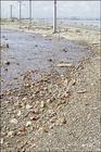
Palisadoes Road, flooded in December 2007.
Anthony R.D. Porter, Contributor
About 130,000 years ago (during the third inter-glacial stage of the Pleistocene Epoch in North America, called the Sangamon), sea levels were much higher than they are today, perhaps by as much as six metres (about 18 feet).
This is evidenced in Jamaica and elsewhere by physical coastal features stranded inland, such as wave-cut notches and elevated coral reefs. Interestingly, there are similar features at about the two-metre mark above present-daysea level.
The general consensus among marine geologists (earth scientists who study the sea and its geologic effects) is that at the end of the Sangamon stage, sea levels dropped quickly - by about four metres - and then stood still for a while and, in the process, carved out another wave-cut notch in the rock outcrops then exposed along the coastline.
Studies also suggest that, about 125,000 years ago, the sea level dropped further to minus 20 metres below present-day sea level. The presence of drowned sea caves and other erosion features at about 60 feet below surface off the coast of Negril bear testimony to this change.
Then, about 20,000 years ago, planet Earth was once again subjected to another glacial epoch in which huge ice sheets covered most of North America and Europe.
In fact, the Canadian geological landscape as we know it today did not come into existence until 12,000 to 10,000 years ago when the last of the ice sheets retreated (i.e., melted) and sea level rose again to its present-day height.
Along sections of the Jamaican coastline, the characteristic wave-cut notches and wave-cut platforms are indelibly carved into the coastal rock formations for all to see.
When Edward Long published his historical account of Jamaica (History of Jamaica, three volumes) in 1774, there was at least one naturally formed opening or channel in the narrow, largely sandy neck of land known as the Palisadoes spit, that forms a nine-mile (almost 14 km) long natural breakwater for Kingston Harbour.
Although not navigable to the sailing ships of that period, the breach - located about midway between Harbour Head (near the Jamaica Gypsum Company wharf) and the roundabout leading into the Norman Manley airport - facilitated the free flow of sea water by tidal action.
Over time, deposition of silt, sand and gravel-size fragments, by long-shore drift combined with wind and wave action, gradually filled the channel and enlarged the spit.
In 1936, the road leading to Plumb Point lighthouse and beyond was finally completed. Today, the very existence of this nine-mile long breakwater, the road, the airport, the cays, and Port Royal, are threatened by external forces beyond our control, and by 2050 all of them could disappear from the map of Jamaica.
"How can this happen?" you will ask.
Being an avid explorer of the outdoors, I ventured north in the early 1960s to Canada to pursue studies in earth science, also called geology, or the geological sciences.
Global warming
While there, I was exposed to glacial geology, a branch which encompasses the study of glaciers and their geologic effects, but 40 years have now passed since I last ventured into the cold, frigid temperatures of the Hudson Bay to observe and study the tundra, polar bears and the masses of snow and arctic-like ice.
Back then, 'global warming' was not a topic we discussed: in fact, I don't recall ever hearing the expression until many years later. But, today, the scientists working in Antarctica, Greenland, Northern Canada and Europe paint a different picture to what I saw, and to what is taking place. To be sure, the pace at which the ice sheets and glaciers are melting is downright scary to frightening.
If the predictions being made are correct, then all of us in Jamaica and the Caribbean need to heed the warnings. We also need to set up a scientifically driven early warning and watchdog system to check and monitor the effects of rising sea levels, caused by increasing temperatures due to the increasing levels of carbon dioxide gas (CO2) being released into the atmosphere by the human race.
One projection put forward by the scientists is for a rise in sea level of 10 feet by as early as 2050. This is equivalent to an average rise of about three inches per year for the next 42 years, but no one can predict whether this will happen gradually over that period of time, or over a shorter period of time due to sudden, unexpected surges in atmospheric temperatures, triggered by other events such as explosive volcanic activity releasing volatile matter, like carbon dioxide, sulphur dioxide, hydrogen sulphide, or nitrogen, into the atmosphere.
Implications
If a 10-ft rise should occur, then Port Royal, the Cays, Palisadoes Road, and Norman Manley Airport will be completely submerged. Even now sections of the existing road surface are almost covered at high tide. Elsewhere in the island, all coastal sections less than 10 feet in height above the high tide mark will be inundated by the sea, including sections of coastal highways, beaches, hotels and other buildings, low-lying swamps, mangroves, Black River Morass, Negril Morass, and the Montego Bay International airport, to name a few: groundwater tables will rise, and weather patterns will change.
In short, planetary meltdown will result in economic, physical and social chaos, and human tragedy will be unprecedented in Jamaica's history, as every aspect of life will be affected - communications, fishing, food supplies, health, insurance, industry, power generation (if we still depend on oil), transportation, and so on.
Is it too much to hope that the scientists are wrong in their predictions? Maybe! But let's not forget that Earth has had a violent history. Dramatic changes have occurred in the past; they will occur again in the future. It is written in the rocks.
Stay informed
So what can we do? What should we do? One thing is obvious, we need to be ever watchful and alert to subtle or unusual physical or chemical or biological changes taking place in our surroundings.
We need to stay informed. And we need to ensure that any and all proposed development projects be carefully scrutinised, assessed and evaluated (especially those planned in coastal regions) by all concerned, be they architects, bankers, contractors, developers, engineers, or politicians, because global changes are occurring that we in Jamaica have little control over. It is a scary prospect, indeed!
Anthony R. D. Porter is a geologist, explorer, and author of three books on Jamaican geology, including 'Bricks and Stones from the Past: Jamaica's Geological Heritage'.