By John Myers, Jr., Staff Reporter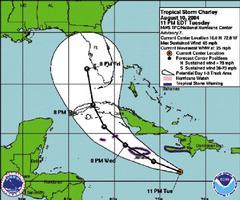
Graphics courtesy of National Oceanic and Atmospheric Administration.
ALL EMERGENCY services have been activated as the country braces for the impact of Tropical Storm Charley, the third such weather system of the 2004 Atlantic Hurricane Season, which is propelling on a treacherous path towards the island.
"We are under a tropical warning and this means that storm conditions, including possible sustained winds of 34 to 63 knots or 63-117 km/h, are expected to affect Jamaica within 24 hours or less," Lawrence Brown, senior forecaster at the National Meteorological Service, told The Gleaner last night.
SLIGHT SHIFT
"There was a slight shift to a more northerly direction which puts the eye of the storm over the western tip of the island..." he said. As a result, he said the island was expected to suffer from more violent winds than were originally projected.
HEAVY THUNDERSTORMS
According to Mr. Brown, the storm, which is moving at more than 43 kilometres per hour, is expected to bring winds of up to 105 kilometres per hour, heavy thunderstorms and showers and extremely rough seas. "We are likely to have smaller trees uprooted and branches of larger trees broken, and it is likely for small buildings that are not well constructed to lose roofs."
Fishers on the cays and banks, especially those on the Morant and Pedro Cays, are advised to return to the mainland, not to venture out to sea, and all small craft operators are being advised to return to port.
"We had a meeting of the National Response Team today (yesterday) and all the agencies have activated their plan and are preparing to support the national effort if that should become necessary," Dr. Bar-bara Carby, director-general of the Office of Disaster Prepared-ness and Emergency Manage-ment (ODPEM), said last night.
The ODPEM is advising the public to take the following precautions:
Ensure that you have enough boards, nails, rope etc., on hand to batten down your property if necessary
If you live in low-lying, coastal or flood-prone areas, be ready to evacuate. Decide on likely evacuation routes now. Plan to stay with family or friends in safer areas or in a public shelter.
Put together an emergency supply kit with enough items to last a few days.
Trim trees and secure loose objects which could become missiles.
All business places should activate their contingency plans.