Edward Robinson, Deborah-Ann C. Rowe, Shakira A. Khan, Contributors
This is another in a series of articles on Hazards of the Jamaican Coastline contributed by the Marine Geology Unit, Department of Geography and Geology, University of the West Indies.
In the previous installment of the Hazards of the Jamaican Coastline series, we mentioned that the Palisadoes has evolved into a complex structure as a result of the way it has developed over the past 5000 years. Five thousand years ago was about the time that sea level reached more or less its present position, ending the spectacular rise from a point some 120 metres below today's level. (For a description of this rise read our previous article 'Will sea level rise and drown Jamaica?' The Gleaner November 25, 2005, pages E5-E6.). This rise and fall of the sea level has occurred several times over the past million years, going up and down like a yo-yo, and it is quite likely that previous incarnations of Palisadoes-like formations existed during the high stands of the ocean through this period. However, we only know about the present one with any certainty. The model for the evolution of the Palisadoes we suggest here assumes that all the present complex has developed since sea level rose to its present position.
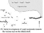
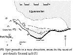
Five thousand years ago there was no Palisadoes as we know it, but the ingredients for its development existed in the form of ocean waves coming from the southeast and river sediment coming down the Hope and Cane Rivers. The accompanying diagrams illustrate the course of the growth of Palisadoes. Note that before growth started, the shallow shelf south of the Liguanea Plain was probably dotted with small cays, similar to today's Lime Cay. The exact locations of these cays are not known.
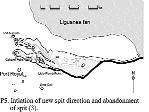
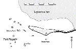
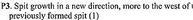
Initially the sediment supply and wave action started to form a spit that gradually extended itself westwards towards the various cays on the island shelf (P1). Eventually this spit had grown as far as the site of the present airport, where it engulfed one or more cays. These probably acted as an anchor for the subsequent extension to the northwest (P2). At some moment in time the currents swirling about this anchor-point initiated spit growth in a new direction, more to the west of the previously formed spit. As this new growth developed, it cut off the supplies of sediment to the former spit, which became inactive, eventually to exist only as a set of shallow banks (P3). A miniature version of an event of this kind can actually be seen today if one drives out to Rocky Point where the old fort is (a party spot today). Here a small, curved spit has thrust itself seawards where no spit existed six months ago. The conditions are not favourable for it to develop much further, but it shows how conditions for spit development can arise quite suddenly.
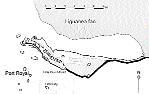
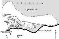
The rest of the story of the development of Palisadoes basically consists of several repetitions of this process of capture of sediment supply through the initiation of spit growth in a new direction, leading to the starvation of the sediment supply and cessation of growth of each former spit in turn (diagrams P4 to P5). The most recent phase in the evolution of Palisadoes appears to have taken place in the last 500 years (P6). When the Spanish first came to Jamaica at the end of the 15th century Port Royal was still an island. Since then it has become more or less firmly joined to the rest of the Palisadoes.